Skip to content Skip to left sidebar Skip to footer

COEHStreets

Additional Stop Sign Implementation – West Side

City crews are continuing stop sign implementation west of Montana Ave.  This includes new stop signs at all intersections that connect to Gail Street, and also 1st and Groschell Street.  Any questions please contact public works Kevin Ore at 406-459-3769.

East Helena Map showing west side stop sign placement.
Click or tap picture for a larger image.

Main Street East Helena – Lane Closure

Starting Monday, September 27th through Thursday, September 30th, traffic on Main Street in front of 15 West Main will be partially closed to east bound traffic. Lane closure is due to a water line repair which is located across from Eagles 4040. Please remain cautious while traveling through this area.

Schools Are Open – New Speed Limits Valley Drive & Near Radley Elementary School

Map of area with new slower speed zones.

Please remember to slow down, schools are open.

The City of East Helena has made some speed limit reductions along Valley Drive south of Prickly Pear Elementary and around Radley Elementary School.

Valley Drive is now a 25MPH zone from Highway 12 to Plant Road and is shown in green on the map. East Clinton street and North Thurman Avenue now have a 15MPH school zone during school hours and is shown in blue on the map.

Please call the City of East Helena Public Works Director Kevin Ore during business hours with any questions at 406-227-5321.

Wylie Drive Daytime Closure & Detour August 9th-20th

Northwestern Energy will be performing work within the City of East Helena for their gas gate station located at 112 Wylie Drive from August 9th through August 20th, 2021. All Wylie Drive traffic between Main Street and Gail Street will be detoured to 3rd Street from 8:30 a.m. to 4:30 p.m.

For a larger image of the closure area, please click or tap here, for a pdf document of the area click or tap here. For more information on the closure/detour, please call East Helena Public Works Director Kevin Ore at 406-227-5321.

City of East Helena 2021 Growth Policy Update – Approved

2021 Growth Policy front cover.

The City of East Helena first adopted a growth policy in 2009 and updated it in 2014. In 2020 and early 2021 the East Helena Planning Board, the public, and important stakeholders, with the financial assistance of a Montana Department of Commerce CDBG grant, went through the public process and updated the 2014 Growth Policy. On May 4, 2021, The East Helena City Council held a public hearing and passed a resolution approving the 2021 Update to the East Helena Growth Policy.

Many thanks goes out to the East Helena Planning Board for their efforts to complete the updated Growth Policy as well as the public participants who gave their input and those that took the 2020 public survey.

Additionally, thank you to the Montana Department of Commerce and their CDBG program for the financial assistance.

Click or tap here, or on the Growth Policy cover, to open or download a PDF copy of the East Helena 2021 Growth Policy.

Seasonal Weight Limit Restrictions for Certain Roads Within Lewis & Clark County

Temporary weight restrictions have gone into effect beginning March 8, 2021 on certain County roads. As frozen ground thaws, base gravel in the roadbed becomes saturated, causing surface break up and premature failure. In these conditions, fully loaded vehicles can cause severe road damage.

The load limits for all restrictions are 7 tons for single axles, 14 tons for tandem axles, or 350 pounds per inch width of tire.

Temporary restrictions will be in place for the following roads in Lewis & Clark County:

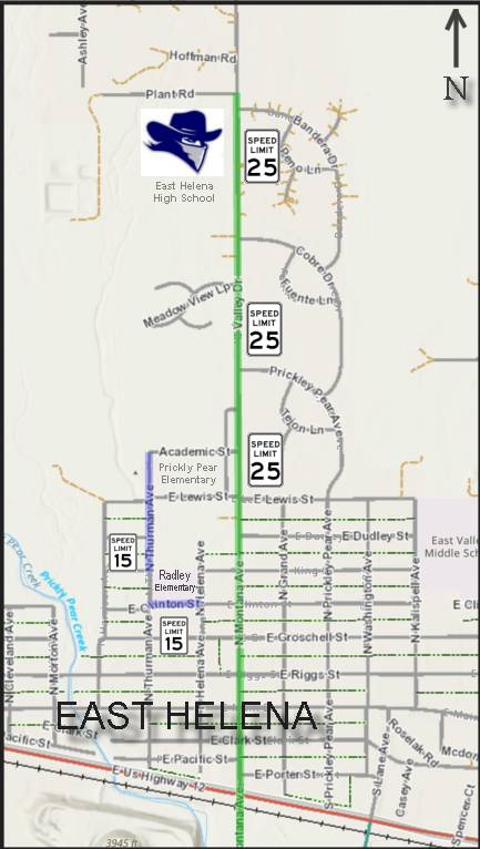
City of East Helena:
• Valley Dr. – Lewis St. to Canyon Ferry Rd.

Greater Helena & East Helena Area:
• Birdseye Rd. – Williams St to Highway 279.
• Causeway Way (Lake Helena Dr.) – Lincoln Rd. East to end of asphalt.
• Collins Dr. South – Lincoln Rd. East to Masonic Home Rd.
• Country Club Ave. – Joslyn St. to Williams St.
• Forestvale Rd. – Green Meadow Dr. to North Montana Ave.
• Highway 284 – Jimtown Rd. to Broadwater County line.
• Masonic Home Rd. – Collins Dr. S. to Frontage Rd.
• Jim Town Rd. Asphalt – Highway 284 to end of asphalt.
• Keir Dr. – Canyon Ferry Rd. to Saffron Ln.
• Masonic Home Rd. – Collins Dr. S. to Frontage Rd.
• McHugh Ln. – Yuhas Ave. to Sierra Rd. W.
• Mill Rd. – Green Meadow Dr. to N. Montana Ave.
• Lake Helena Dr. – Causeway to Lincoln Rd. E.
• North Montana Ave. – North of Lincoln Rd.
• Sierra Rd. East – Frontage Rd. to Floweree Dr.
• Sierra Rd. West – Frontage Rd. to Green Meadow Dr.
• Williams St. – Highway 12 to Birdseye Rd.
• Wylie Dr. – Canyon Ferry Rd. to York Rd.

Lincoln Area:
• B Street – At Stemple Pass Rd.
• C Street – At Stemple Pass Rd.
• D Street – At Stemple Pass Rd.
• 1 Ave. South – South of Highway 200
• 6th Ave. – North and South of Highway 200
• 7th Ave. – South of Highway 200
• 8th Ave. – North and South of Highway 200
• 9th Ave. – At Highway 200
• Spring Creek Ln. – Highway 200 to end of asphalt
• Sleepy Hollow Ln. – North of Highway 200
• Sucker Creek Rd. – Highway 200 to end of asphalt

Permanent restrictions remain in place and are needed on roads with sub-standard base material and double chip seal. Normal highway loading can cause severe damage to roads and lead to costly repairs. These roads are:
• Applegate Dr. South – Lincoln Rd. to Norris Rd.
• Beartooth Rd. – Frontage Rd. to end of asphalt.
• Bel Air Subdivision – Entire Subdivision
• Colorado Gulch Dr. – Highway 12 to end of asphalt.
• Crestwood Estates – Entire Subdivision
• Floweree Dr. – Sierra Rd. East to York Rd.
• Franklin Mine Rd. – Green Meadow Dr. to end of asphalt.
• John G. Mine Rd. East – Green Meadow Dr. to North Montana Ave.
• Lake Helena Dr. South – York Rd. to Canyon Ferry Rd.
• Middlemas Rd. – Montana Ave. to end of road.
• Motsiff Rd. – McHugh Ln. to North Montana Ave.
• Norris Rd. – Green Meadow Dr. to end of road.

Restriction information is online at https://www.lccountymt.gov/public-works/roads-and-bridges.html